
In my new book, Creative Historical Thinking, I have a chapter about the history of my house, and all of the different creative ways you can use to learn more about your property.
I end the chapter by saying that I don’t know what I will discover next, nor how I will learn more about my house, but I know I will.
Today, the source of new information is a set of aerial photographs from 1980, 1987, and 1992. My house was built in 1986, so obviously it doesn’t appear in the 1980 photograph, which only includes my neighbor’s house and a barn (my barn). It is clear from the photographs that the property was once almost treeless. Now it is covered with pines, locust, and a few maple. A few of the medium-size trees in the photographs from the 1980s I now recognize as my own large trees.
The vintageaerial.com website is very well organized, and it is quite easy to use a map to locate your house and check if they have any photographs. While you have to pay for a good image, what you can learn from the free image proofs is a treasure enough for the historians among us.

- My property in a photograph from 1980. The trailer on the left is on the neighboring lot. The barn is now mine, and the space to the right of the barn had just been parceled and designated for new construction.

- In this photography from 1987, my barn still had all of its siding. The large tree near the barn must have fallen long ago, and I know of no remnant of it. The large tree behind the neighbor’s trailer is a still standing silver maple.

- This photograph from 1987 shows my neighbor’s lot, and most of my 5 acres. The house (cabin) had just been built in the previous year. The small shed(?) behind the barn is information to me.
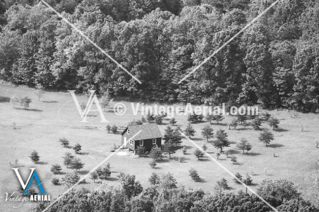
- All those darn pine trees. I wish he would have cut them before they took over! The old growth forest in the background still stands.


[…] give the site a shot – the old aerial photos here are remarkable. As you can see from this Georgetown University professor’s search, homeowners can develop a visual timeline of their property’s […]
LikeLike