
Since moving to Hampshire County, W.V. five years ago, I have been researching the history of my property and the county more generally. One problem in this research has been the lack of good, early maps. Early properties were defined by “metes and bounds” from the old Oak to the Chestnut, to the ridge, and then so many paces down to the creek. Seldom have properties remained the same, so it is very possible that if you can trace back your own property’s deed one hundred years or more, the property might be not only in a different shape now, but also potentially even in a different location, if it moved amoeba-like across the landscape.
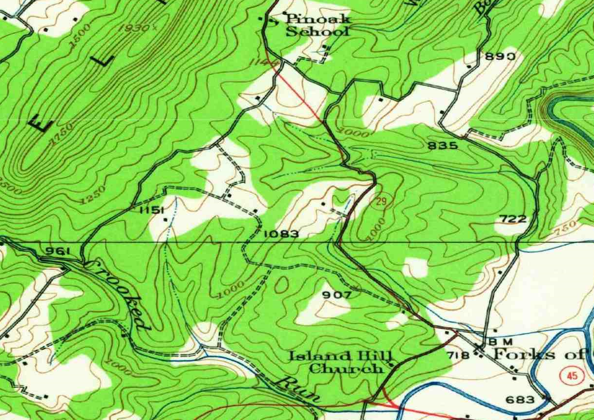
From what I can tell, the earliest topographical surveys of land in the county were made in 1873 and then again in 1894, 1923, 1937, 1943, and 1973, etc., with the most recent published survey from 2019. These surveys are useful for finding the paths of old abandoned roads or the locations of houses on the landscape. Some, like the 1937 topographical survey (show below) is also useful for indicating what land was forested (green) and what land was under cultivation (white).
When Hampshire County was first settled in the 1750s, its rivers were the primary paths of travel. The earliest geographical depiction of the county that I have been able to find comes from a 1755 French map, where we see “la Branche de Sud” (the South Branch) flowing through Pearsals (Romney). The names on the maps are not settlements as much as settlers, or settler families. In addition to Pearsal or “Pearsall” there was the Phipps, Parkers, Johnstons, Mackeyes, and Smiths.

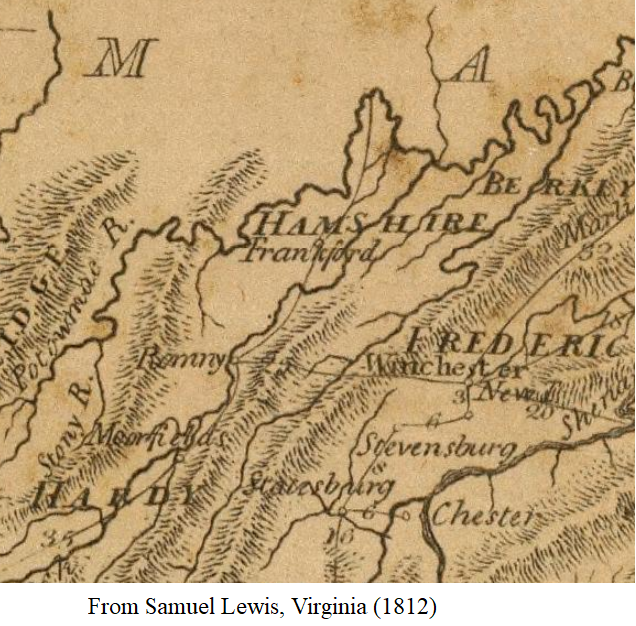
Defining property and maintaining the roads (along with keeping the peace) were the main objectives of county government, in Hampshire and anywhere really in early 19th century America. It is disappointing, given the effort so many spent to keep up the roads, that they seldom thought to record a history of them, when they started, where they went, when they were abandoned, or even how they were funded. Historians of early Hampshire County have to rely on less than convincing maps of the state of Virginia, at fairly low scale. Samuel Lewis’s 1812 map of Virginia shows one road (essentially the present route 50) from Winchester to Romney, and another road running North/South from Moorefield to Frankfort (present-day Fort Ashby). Early mapmakers were concerned with the rivers as much as the roads. They weren’t, always, too concern with spelling. Note “Romny” and “Hamshire” instead of Romney and Hampshire.
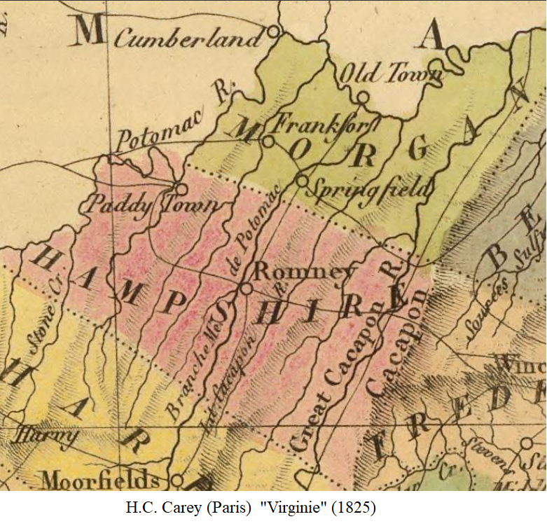
An 1825 map of Virginia, published in Paris, France, is not much of an improvement. The rivers are labelled clearly, and the map includes Romney, Frankfort, Springfield, and Paddy Town (Keyser). If you find that your flux capicator has transported you back to this period, remember to use the correct place names to fit in. In this map, the borders of the county are obviously different than they are at present.
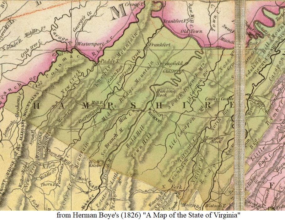
Herman Boye’s 1826 map of Virginia gives a more accurate portrayal of the county’s roads. Hampshire County has always been a marginal place, in more ways than one. Located on the eastern side of West Virginia, it is neglected in the state legislature, ignored on the state public radio programs that focus instead on poverty in coal country. It is not part of the West Virginia “panhandle” nor clearly a part of some other geographical descriptor that would help people recall where it is. The county’s marginal position, formerly on the frontier of the state of Virginia, then on the edge of West Virginia, means that it is often on the corner of state maps, sometimes even covered or partially obscured by a map key or compass rose. Here, the fold of the page splits the county map.
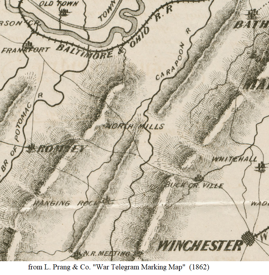
A fury of map-making in and around Virginia occurred during the Civil War, for the obvious reason that two armies were trying to dance around each other without getting killed or lost. This 1862 War Telegram Map of Virginia shows North Mills (North River Mills) and the Carapoon (an obvious typo or misunderstanding of the Cacapon River). I would support a movement to change the name to “Carapoon” if only among the historians in the county. Notice that while rivers and mountains are important features, the Baltimore & Ohio R.R. is also a central feature of concern.
In 1873, a map of Mineral and Hampshire County was produced. This map shows the counties divided in districts. Some of the old roads on this map have long been abandoned, replaced by modern routes for automobiles. It is curious, as well, to read of place names like “Forks of Cacapon” which was then something of real village with a mill, store, and Post Office, but which is now only a geographical descriptor for a spot of land with a few houses on it. (Click on the map for a larger view).

We proceed with an 1895 map that purports to show the state of Virginia as it was during the War of the Rebellion, a.k.a the Civil War, a.k.a. (in certain parts) the War of Northern Aggression, or what I, a Yankee invader in the South, have sometimes jokingly referred to as “the War of Northern Arrogance”.
Another one from 1895 about which I don’t have much to say except that it’s curious that Caudy’s Castle is marked on the map, when, as far as I know, that was never the name of a settled place, only a mountain feature along the Cacapon River.

Rand McNally was making maps before there were automobiles, and back in 1889 he (or they, I guess), were not very interested in the roads in Hampshire County for this map of West Virginia. If you needed to get anywhere in Hampshire County at the time, I think you needed to ask the locals which dirt road was best.

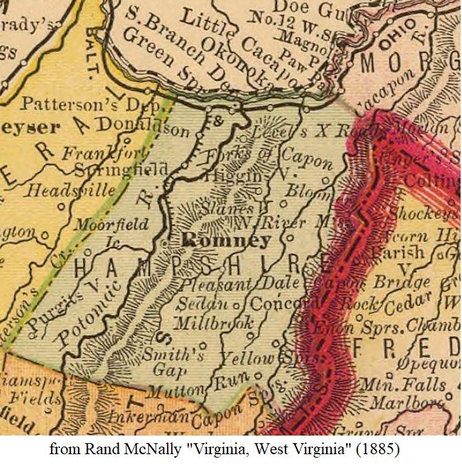
In the previous map, and in the one below from 1885, we see what appears to be a canal running through Springfield. I don’t know much about that corner of the county, so perhaps someone better informed than I can jump in with a comment about what is/ was going on there.
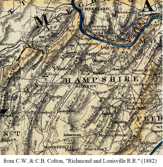
Finally, I leave you with a corner of the 1882 Richmond & Louisville R.R. Map, in which we see many, fairly straight roads darting about the county. Obviously, if you look at the more detailed topographical maps from this period, you will find that these roads were anything but straight, and that the mapmaker here had to only approximate their direction for the scale of the map.


Thank you so much for doing this research I descend from the Andersons of Anderson Bottom. I also descend form the Bosleys of New Creek ( Claysville). Thank you again. Great Work
LikeLike
I belong to the one school room group of Hampshire County. Bob Smith is heading this group. We are searching for a one room school called Red Hill School in Capon, WV. We are planning our final trip in the early Fall before winter sets in. We have been having a problem trying to locate this school, that is, if it is still standing. I have spoken with Steve Bailes and received some information from Dan Oates but not the location. Any information would be greatly appreciated.
LikeLike
I can’t help with this Marvin, but I’ll leave your comment up and maybe someone passing through this page will be able to respond. Best of luck, Michael
LikeLike
I was looking through deed books in Romney today and noticed that in October 1827 a jury was convened to assess the impact to Jesse Sharpless’ land by a proposed road “from George Bannick’s smith shop to the craigs of the mouth of the Savage (Deed Book 26, pp. 54-55). This area was part of Hampshire at the time but now lies in Mineral County. I wonder what that road was or is today.
LikeLike
In the West Virginia 1889 Map the “canal” is probably the small southern section of the Hampshire County local railroad connecting with the B&O main line from Baltimore to Cumberland. Later in the early 1900’s the Hampshire Southern RR, which terminated in Romney, was extended southerly to Moorefield and to Petersburg WV.
LikeLike